Open the complete capitals atlas and jurisdiction register
National extent
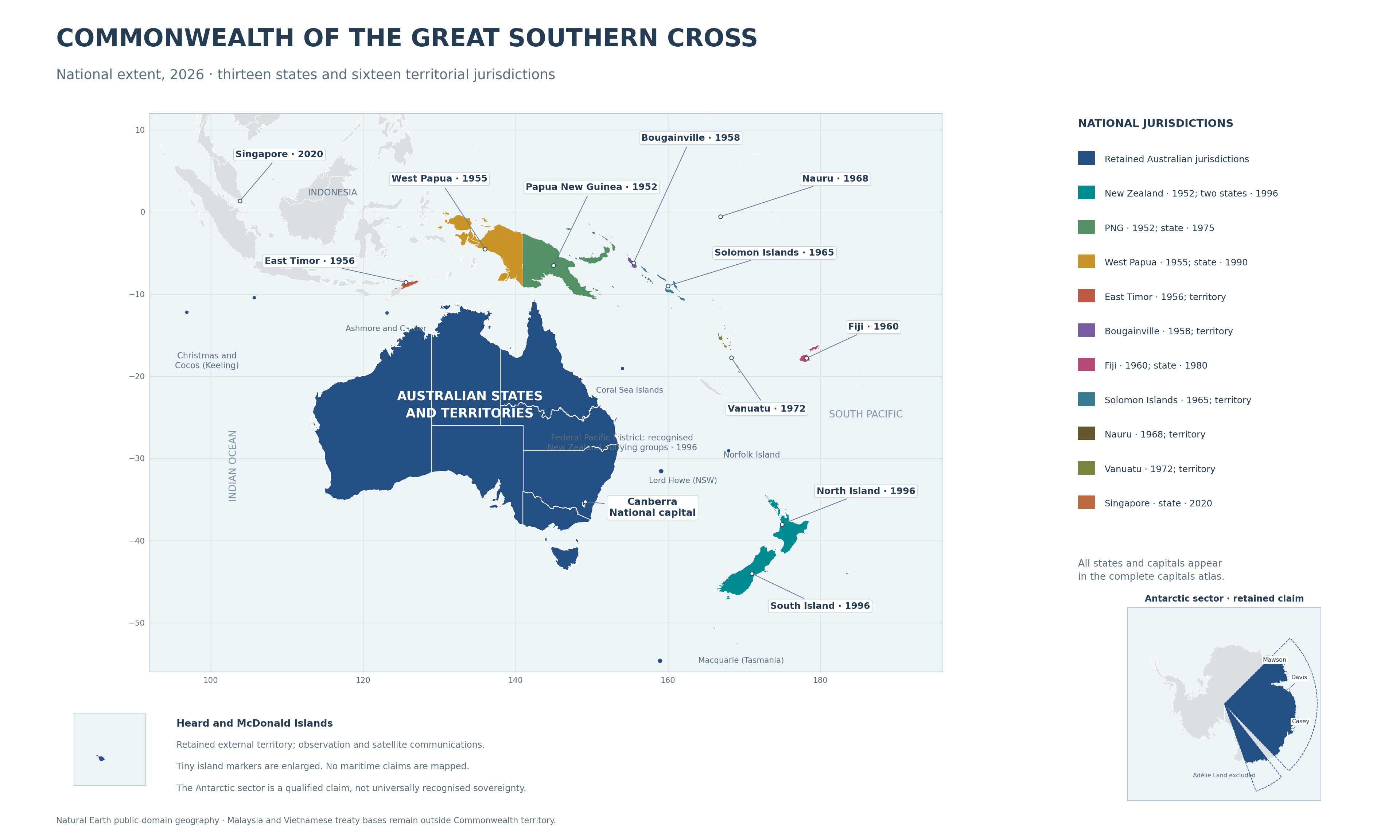
The national map includes the retained Australian mainland, Tasmania and all internal and external territories; North and South Island; Papua New Guinea; West Papua; East Timor; Bougainville; Fiji; the Solomon Islands; Nauru; Vanuatu; and Singapore. North and South Island were formed by New Zealand’s 1996 division. Papua New Guinea, West Papua and Bougainville are separate administrations.
Australia and its islands
New South Wales, Victoria, Western Australia, South Australia and Tasmania retain their historical state boundaries. Queensland divided into North Queensland and South Queensland in 1995, with Townsville and Brisbane as capitals. North Queensland retains year-round UTC+10; South Queensland adopts seasonal daylight saving. The Northern Territory, Australian Capital Territory and Jervis Bay Territory remain territorial jurisdictions. Lord Howe belongs to NSW and Macquarie to Tasmania.
External territories
Christmas Island, Cocos (Keeling), Norfolk, Ashmore and Cartier, the Coral Sea Islands, Heard and McDonald Islands and the Australian Antarctic Territory retain distinct entries. Tiny islands are marked at enlarged scale; a marker is not a claim to all surrounding sea. The Antarctic sector remains a claim, with Adélie Land excluded and international treaty qualifications retained.
Capitals and administrative centres
The register lists every inhabited jurisdiction's capital or administrative centre. Whangārei is North Island's capital from the 1996 division, and Christchurch is South Island's. Wellington retains its signals organisation and hosts the Federal Pacific District secretariat. Port Moresby, Suva and Jayapura serve their respective states after the 1975, 1980 and 1990 promotions. Singapore is a state from 2020. Remote uninhabited groups use responsible offices rather than invented cities. Jervis Bay is the national capital's port; Sydney and Fremantle remain principal fleet bases.
Admission and statehood
The Swell Act restricts voluntary admission to island nations of Southeast Asia and the Pacific. A locally supported admission act is separate from promotion to statehood. Population, advanced public services and viable institutions determine eligibility, while smaller islands may retain territory status. New Zealand entered directly as a state in 1952; other incorporated societies retain their individual names and jurisdictional identities.
Map sources
Country and province boundaries use Natural Earth public-domain geography. The Queensland settlement line uses Queensland Government local-government outlines as a cartographic reference; these are contemporary outlines, not a reconstruction of 1995 electoral boundaries. Australian state boundaries, New Zealand regional geometry and sourced island locations are used in the national atlas. Maps omit maritime claims and do not turn an alliance into annexation.
Federal Pacific District
The district administers recognised New Zealand outlying islands separately from North and South Island. Chatham, Kermadec, Three Kings and the recognised southern island groups fall within its register. Cook Islands, Niue and Tokelau require negotiated association instruments and are not automatically incorporated. Maps distinguish these arrangements from national sovereignty and foreign treaty access.
Vanuatu, 1972
Vanuatu joined as a separate territory in 1972, with Port Vila as capital, local institutions, protected languages and representation in both federal houses. Its public-development compact preceded expansion of Eastern Fleet support. It remained a territory in 2026.